
Headline:
Flash Flood Warning issued April 5 at 11:06AM CDT until April 5 at 3:15PM CDT by NWS Paducah KY
Event:
Flash Flood Warning
Urgency:
Immediate
Effective:
April 5, 2025 - 9:06am
Expires:
April 5, 2025 - 1:15pm
Description:
FFWPAH
The National Weather Service in Paducah has extended the
* Flash Flood Warning for...
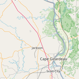
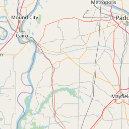
Cape Girardeau County in southeastern Missouri...
* Until 315 PM CDT.
* At 1106 AM CDT, Doppler radar indicated thunderstorms have
produced heavy rain across the warned area. Between 3 and 6 inches
of rain have fallen. Additional rainfall amounts up to 2 inches
are possible in the warned area today. Flash flooding is ongoing
or expected to begin shortly.
HAZARD...Flash flooding caused by thunderstorms.
SOURCE...Radar.
IMPACT...Flash flooding of small creeks and streams, urban
areas, highways, streets and underpasses as well as
other poor drainage and low-lying areas.
* Some locations that will experience flash flooding include...
Cape Girardeau, Jackson, Bollinger Mill State Historic Site,
Delta, Gordonville, Dutchtown, Burfordville, Millersville, Daisy,
Oak Ridge, Whitewater, Allenville, Pocahontas and Old Appleton.
Instruction:
Turn around, don't drown when encountering flooded roads. Most flood
deaths occur in vehicles.
Be aware of your surroundings and do not drive on flooded roads.
Area Description:
Cape Girardeau, MO
Forcast Office:
NWS Paducah KY

Leaflet | OSM Mapnik