
Headline:
Flash Flood Warning issued April 5 at 9:51PM CDT until April 6 at 3:00AM CDT by NWS Memphis TN
Event:
Flash Flood Warning
Urgency:
Immediate
Effective:
April 5, 2025 - 7:51pm
Expires:
April 6, 2025 - 1:00am
Description:
FFWMEG
The National Weather Service in Memphis has issued a
* Flash Flood Warning for...
Chester County in Tennessee...
Fayette County in Tennessee...
Hardeman County in Tennessee...
Hardin County in Tennessee...
Haywood County in Tennessee...
Lauderdale County in Tennessee...
McNairy County in Tennessee...
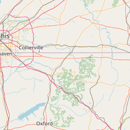
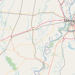
Shelby County in Tennessee...
Tipton County in Tennessee...
* Until 300 AM CDT.
* At 951 PM CDT, runoff from thunderstorms producing heavy rainfall
will continue to result in flash flooding across much of northwest
Tennessee. Between 2 and 6 inches of rain have fallen. Additional
rainfall amounts of 1 to 2 inches are possible in the warned area.
Flash flooding is ongoing.
HAZARD...Flash flooding caused by thunderstorms.
SOURCE...Radar.
IMPACT...Flash flooding of small creeks and streams, urban
areas, highways, streets and underpasses as well as
other poor drainage and low-lying areas.
* Some locations that will experience flash flooding include...
Bartlett, Collierville, Germantown, Brownsville, Millington,
Covington, Ripley, Savannah, Henderson, Bolivar, Selmer, Luxora,
Chickasaw State Forest, Chickasaw State Park, Big Hill Pond State
Park, Cordova, Fort Pillow State Park, Meeman Shelby Forest State
Park, T O Fuller State Park and Pickwick Landing State Park.
Instruction:
Turn around, don't drown when encountering flooded roads. Most flood
deaths occur in vehicles.
Area Description:
Chester, TN; Fayette, TN; Hardeman, TN; Hardin, TN; Haywood, TN; Lauderdale, TN; McNairy, TN; Shelby, TN; Tipton, TN
Forcast Office:
NWS Memphis TN


Leaflet | OSM Mapnik