
Headline:
Flash Flood Warning issued April 5 at 9:57PM CDT until April 6 at 3:00AM CDT by NWS Memphis TN
Event:
Flash Flood Warning
Urgency:
Immediate
Effective:
April 5, 2025 - 7:57pm
Expires:
April 6, 2025 - 1:00am
Description:
FFWMEG
The National Weather Service in Memphis has issued a
* Flash Flood Warning for...
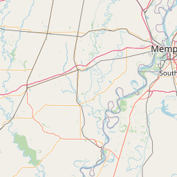
Southeastern Lee County in eastern Arkansas...
Southeastern Phillips County in eastern Arkansas...
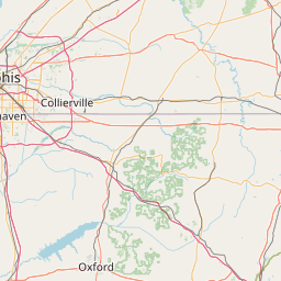
Benton County in northeastern Mississippi...
Coahoma County in northwestern Mississippi...
DeSoto County in northwestern Mississippi...
Northern Lafayette County in northwestern Mississippi...
Marshall County in northwestern Mississippi...
Panola County in northwestern Mississippi...
Quitman County in northwestern Mississippi...
Tate County in northwestern Mississippi...
Tunica County in northwestern Mississippi...
* Until 300 AM CDT.
* At 957 PM CDT, runoff from thunderstorms producing heavy rainfall
will continue to result in flash flooding across much of northwest
Mississippi. Between 2 and 4 inches of rain have fallen in the
past 6 hours. Additional rainfall amounts of 1 to 2 inches are
possible in the warned area. Flash flooding is ongoing or expected
to begin shortly.
HAZARD...Flash flooding caused by thunderstorms.
SOURCE...Radar.
IMPACT...Flash flooding of small creeks and streams, urban
areas, highways, streets and underpasses as well as
other poor drainage and low-lying areas.
* Some locations that will experience flash flooding include...
Southaven, Olive Branch, Horn Lake, Clarksdale, Hernando,
Senatobia, Holly Springs, Batesville, John W Kyle State Park, Wall
Doxey State Park, Memphis, Lamar, Marks, Sardis, Coldwater,
Lambert, Byhalia, Jonestown, Como and Friars Point.
Instruction:
Turn around, don't drown when encountering flooded roads. Most flood
deaths occur in vehicles.
Area Description:
Lee, AR; Phillips, AR; Benton, MS; Coahoma, MS; DeSoto, MS; Lafayette, MS; Marshall, MS; Panola, MS; Quitman, MS; Tate, MS; Tunica, MS
Forcast Office:
NWS Memphis TN


Leaflet | OSM Mapnik