
Headline:
Flash Flood Warning issued April 6 at 12:04AM EDT until April 6 at 2:15AM EDT by NWS Louisville KY
Event:
Flash Flood Warning
Urgency:
Immediate
Effective:
April 5, 2025 - 9:04pm
Expires:
April 5, 2025 - 11:15pm
Description:
FFWLMK
The National Weather Service in Louisville has extended the
* Flash Flood Warning for...
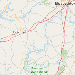
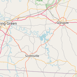
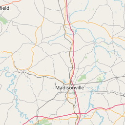
Hardin County in central Kentucky...
Hart County in central Kentucky...
Larue County in central Kentucky...
* Until 215 AM EDT /115 AM CDT/.
* At 1204 AM EDT /1104 PM CDT/, local law enforcement reported flash
flooding in near Elizabethtown and near Munfordville. Secondary
road closures in Elizabethtown due to rising water. One lane
closed on Interstate 65 near Munfordville. . Additional rainfall
amounts of 0.5 to 1 inch are possible in the warned area. Flash
flooding is already occurring.
HAZARD...Flash flooding caused by heavy rain.
SOURCE...Law enforcement reported.
IMPACT...Flash flooding of small creeks and streams, urban
areas, highways, streets and underpasses as well as
other poor drainage and low-lying areas.
* Some locations that will experience flash flooding include...
Elizabethtown, Hodgenville, Munfordville, Horse Cave, Upton,
Sonora, Bonnieville, Talley, Nolin and Vento.
Instruction:
Turn around, don't drown when encountering flooded roads. Most flood
deaths occur in vehicles.
Be aware of your surroundings and do not drive on flooded roads.
Area Description:
Hardin, KY; Hart, KY; Larue, KY
Forcast Office:
NWS Louisville KY
Leaflet | OSM Mapnik