
Headline:
Flash Flood Warning issued April 5 at 11:06PM CDT until April 6 at 3:00AM CDT by NWS Memphis TN
Event:
Flash Flood Warning
Urgency:
Immediate
Effective:
April 5, 2025 - 9:06pm
Expires:
April 6, 2025 - 1:00am
Description:
FFWMEG
The National Weather Service in Memphis has extended the
* Flash Flood Warning for...
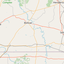
Alcorn County in northeastern Mississippi...
Eastern Benton County in northeastern Mississippi...
Western Prentiss County in northeastern Mississippi...
Tippah County in northeastern Mississippi...
Northwestern Tishomingo County in northeastern Mississippi...
Union County in northeastern Mississippi...
* Until 300 AM CDT.
* At 1106 PM CDT, Emergency management reported thunderstorms
producing heavy rain across the warned area. Between 1 and 3
inches of rain have fallen. Additional rainfall amounts of 1 to 2
inches are possible in the warned area. Flash flooding is already
occurring.
HAZARD...Life threatening flash flooding. Thunderstorms
producing flash flooding.
SOURCE...Emergency management reported.
IMPACT...Life threatening flash flooding of creeks and streams,
urban areas, highways, streets and underpasses.
* Some locations that will experience flash flooding include...
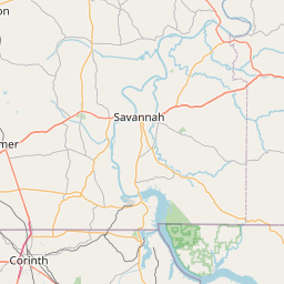
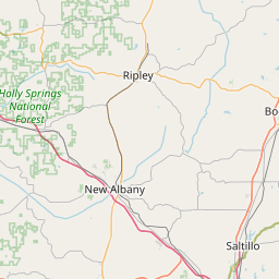
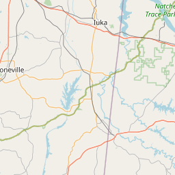
Corinth, Booneville, New Albany, Ripley, Baldwyn, Burnsville, Blue
Mountain, Ecru, Jumpertown, Glen, Keownville, Hinkle, Theo,
Wheeler, Gravestown, Thrashers, New Harmony, Canaan, Leedy and
Etta.
Residents are being evacuated in some areas of Alcorn County.
Instruction:
Turn around, don't drown when encountering flooded roads. Most flood
deaths occur in vehicles.
Be especially cautious at night when it is harder to recognize the
dangers of flooding.
Area Description:
Alcorn, MS; Benton, MS; Prentiss, MS; Tippah, MS; Tishomingo, MS; Union, MS
Forcast Office:
NWS Memphis TN


Leaflet | OSM Mapnik