
Headline:
Flash Flood Warning issued April 5 at 11:24PM CDT until April 6 at 6:15AM CDT by NWS Nashville TN
Event:
Flash Flood Warning
Urgency:
Immediate
Effective:
April 5, 2025 - 9:24pm
Expires:
April 6, 2025 - 4:15am
Description:
FFWOHX
The National Weather Service in Nashville has extended the
* Flash Flood Warning for...
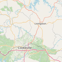
Clay County in middle Tennessee...
Northwestern De Kalb County in middle Tennessee...
Jackson County in middle Tennessee...
Macon County in middle Tennessee...
Western Overton County in middle Tennessee...
Northwestern Putnam County in middle Tennessee...
Smith County in middle Tennessee...
Northeastern Sumner County in middle Tennessee...
Trousdale County in middle Tennessee...
Eastern Wilson County in middle Tennessee...
* Until 615 AM CDT Sunday.
* At 1124 PM CDT, Doppler radar indicated thunderstorms producing
heavy rain across the warned area. Flash flooding is ongoing or
expected to begin shortly.
HAZARD...Flash flooding caused by thunderstorms.
SOURCE...Radar.
IMPACT...Flash flooding of small creeks and streams, urban
areas, highways, streets and underpasses as well as
other poor drainage and low-lying areas.
* Some locations that will experience flash flooding include...
Cookeville, Lebanon, Lafayette, Livingston, Carthage, Celina,
Gainesboro, Hartsville, Algood, Westmoreland, Watertown, Baxter,
Gordonsville, Red Boiling Springs, Hickman, South Carthage,
Alexandria, Granville, Pleasant Shade and Whitleyville.
Instruction:
Turn around, don't drown when encountering flooded roads. Most flood
deaths occur in vehicles.
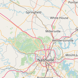
Area Description:
Clay, TN; De Kalb, TN; Jackson, TN; Macon, TN; Overton, TN; Putnam, TN; Smith, TN; Sumner, TN; Trousdale, TN; Wilson, TN
Forcast Office:
NWS Nashville TN


Leaflet | OSM Mapnik