
Headline:
Flash Flood Warning issued April 6 at 4:15AM CDT until April 6 at 7:30AM CDT by NWS Nashville TN
Event:
Flash Flood Warning
Urgency:
Immediate
Effective:
April 6, 2025 - 2:15am
Expires:
April 6, 2025 - 5:30am
Description:
FFWOHX
The National Weather Service in Nashville has extended the
* Flash Flood Warning for...
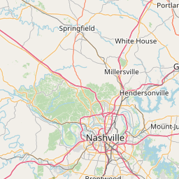
Northeastern Cheatham County in middle Tennessee...
Northeastern Davidson County in middle Tennessee...
Northeastern Montgomery County in middle Tennessee...
Robertson County in middle Tennessee...
Sumner County in middle Tennessee...
Northwestern Wilson County in middle Tennessee...
* Until 730 AM CDT.
* At 415 AM CDT, Thunderstorms produced heavy rain across the warned
area. Between 1.5 and 3 inches of rain have fallen. Flash flooding
is ongoing.
HAZARD...Flash flooding caused by thunderstorms.
SOURCE...Radar.
IMPACT...Flash flooding of small creeks and streams, urban
areas, highways, streets and underpasses as well as
other poor drainage and low-lying areas.
* Some locations that will experience flash flooding include...
Gallatin, Springfield, Hendersonville, Goodlettsville, White
House, Millersville, Greenbrier, Coopertown, Westmoreland,
Ridgetop, Cross Plains, Portland, Pleasant View, Orlinda, Adams,
Cedar Hill, Mitchellville, Cottontown, Oak Grove and Bledsoe Creek
State Park.
Instruction:
Turn around, don't drown when encountering flooded roads. Most flood
deaths occur in vehicles.
Area Description:
Cheatham, TN; Davidson, TN; Montgomery, TN; Robertson, TN; Sumner, TN; Wilson, TN
Forcast Office:
NWS Nashville TN

Leaflet | OSM Mapnik