
Headline:
Flood Warning issued April 5 at 11:57AM EDT until April 6 at 11:00AM EDT by NWS Louisville KY
Event:
Flood Warning
Urgency:
Expected
Effective:
April 5, 2025 - 8:57am
Expires:
April 6, 2025 - 8:00am
Description:
* WHAT...Flooding caused by excessive rainfall is expected.
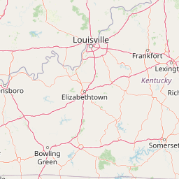
* WHERE...A portion of central Kentucky, including the following
counties, Anderson, Bourbon, Boyle, Casey, Clark, Fayette,
Franklin, Garrard, Harrison, Jessamine, Lincoln, Madison, Marion,
Mercer, Nicholas, Scott, Washington and Woodford.
* WHEN...Until 1100 AM EDT Sunday.
* IMPACTS...Flooding of rivers, creeks, streams, and other low-lying
and flood-prone locations is imminent or occurring. Numerous roads
remain closed due to flooding. Streams continue to rise due to
excess runoff from earlier rainfall. Low-water crossings are
inundated with water and may not be passable.
* ADDITIONAL DETAILS...
- At 1156 AM EDT, Flooding is already occurring in the warned
area. Between 4 and 7 inches of rain have fallen. Due to the
widespread amount of high water, and additional rainfall
expected, this warning will extend into Sunday morning.
- Additional rainfall amounts of 2 to 5 inches are possible in
the warned area.
- Some locations that will experience flooding include...
Lexington, Richmond, Georgetown, Frankfort, Nicholasville,
Winchester, Danville, Lawrenceburg, Versailles and Paris.
- http://www.weather.gov/safety/flood
Instruction:
Turn around, don't drown when encountering flooded roads. Most flood
deaths occur in vehicles.
Area Description:
Anderson, KY; Bourbon, KY; Boyle, KY; Casey, KY; Clark, KY; Fayette, KY; Franklin, KY; Garrard, KY; Harrison, KY; Jessamine, KY; Lincoln, KY; Madison, KY; Marion, KY; Mercer, KY; Nicholas, KY; Scott, KY; Washington, KY; Woodford, KY
Forcast Office:
NWS Louisville KY
Leaflet | OSM Mapnik