
Headline:
Flood Warning issued April 6 at 8:26AM CDT until April 6 at 6:00PM CDT by NWS Memphis TN
Event:
Flood Warning
Urgency:
Expected
Effective:
April 6, 2025 - 6:26am
Expires:
April 6, 2025 - 4:00pm
Description:
* WHAT...Flooding caused by excessive rainfall is expected.
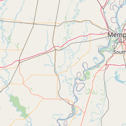
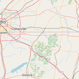
* WHERE...A portion of North Mississippi, including the following
counties, Calhoun, Chickasaw, Lafayette, Lee, Panola, Pontotoc,
Tallahatchie, Union and Yalobusha.
* WHEN...Until 600 PM CDT Sunday.
* IMPACTS...Flooding of rivers, creeks, streams, and other low-lying
and flood-prone locations is imminent or occurring.
* ADDITIONAL DETAILS...
- At 826 AM CDT, Doppler radar indicated heavy rain due to
thunderstorms. Flooding is ongoing or expected to begin
shortly in the warned area. Between 2 and 5 inches of rain
have fallen.
- Additional rainfall amounts up to 0.5 inches are possible in
the warned area.
- Some locations that will experience flooding include...
Pontotoc, Houston, Water Valley, Trace State Park, George
Payne State Park, Bruce, Calhoun City, Vardaman, Derma,
Coffeeville, Ecru, Pittsboro, Slate Springs, Banner, Tula,
Paris, Randolph, Denmark, Pyland and Velma.
- http://www.weather.gov/safety/flood
Instruction:
Turn around, don't drown when encountering flooded roads. Most flood
deaths occur in vehicles.
Area Description:
Calhoun, MS; Chickasaw, MS; Lafayette, MS; Lee, MS; Panola, MS; Pontotoc, MS; Tallahatchie, MS; Union, MS; Yalobusha, MS
Forcast Office:
NWS Memphis TN


Leaflet | OSM Mapnik