
Headline:
Severe Thunderstorm Warning issued March 31 at 3:11AM EDT until March 31 at 4:15AM EDT by NWS Blacksburg VA
Event:
Severe Thunderstorm Warning
Urgency:
Immediate
Effective:
March 31, 2025 - 12:11am
Expires:
March 31, 2025 - 1:15am
Description:
SVRRNK
The National Weather Service in BLACKSBURG has issued a
* Severe Thunderstorm Warning for...
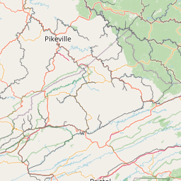
Western Giles County in southwestern Virginia...
Northern Smyth County in southwestern Virginia...
Tazewell County in southwestern Virginia...
Bland County in southwestern Virginia...
Northwestern Wythe County in southwestern Virginia...
Summers County in southeastern West Virginia...
Mercer County in southeastern West Virginia...
Western Monroe County in southeastern West Virginia...
* Until 415 AM EDT.
* At 310 AM EDT, severe thunderstorms were located along a line
extending from near Davenport to near Amherstdale-Robinette, moving
east at 55 mph.
HAZARD...60 mph wind gusts.
SOURCE...Radar indicated.
IMPACT...Expect damage to roofs, siding, and trees.
* Locations impacted include...
Bluefield...
Wytheville...
Bland...
Princeton...
Richlands...
Tazewell...
and Hinton.
This includes The following Location Mercer County Airport.
Instruction:
Prepare immediately for damaging winds. For your safety, move to an
interior room on the lowest floor of a sturdy building. Stay away
from windows.
When it is safe to do so, please send your reports of hail of any
size, as well as reports of any wind damage, including downed trees
or large limbs, to the National Weather Service by calling toll free
at 1...8 6 6...2 1 5...4 3 2 4. Reports and pictures can also be
shared on the National Weather Service Blacksburg Facebook page and
on Twitter.
Area Description:
Bland, VA; Giles, VA; Smyth, VA; Tazewell, VA; Wythe, VA; Mercer, WV; Monroe, WV; Summers, WV
Forcast Office:
NWS Blacksburg VA


Leaflet | OSM Mapnik