
Headline:
Severe Thunderstorm Warning issued April 2 at 6:17AM CDT until April 2 at 6:30AM CDT by NWS Tulsa OK
Event:
Severe Thunderstorm Warning
Urgency:
Immediate
Effective:
April 2, 2025 - 4:17am
Expires:
April 2, 2025 - 4:30am
Description:
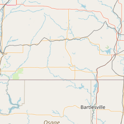
At 617 AM CDT, severe thunderstorms were located along a line
extending from near Edna to 2 miles south of Turley, moving east at
55 mph.
HAZARD...60 mph wind gusts and quarter size hail.
SOURCE...Radar indicated.
IMPACT...Hail damage to vehicles is expected. Expect wind damage to
roofs, siding, and trees.
Locations in or near the path include...
Sand Springs... Wann...
Mannford... Dewey...
Bartlesville Municipal Airport... Collinsville...
Sperry... Skiatook...
Watova... Ramona...
Vera... Talala...
Wolco... Owasso...
Westport... New Alluwe...
Keystone State Park... Walnut Creek State Park...
Lenapah... South Coffeyville...
This includes Interstate 44 between mile markers 216 and 233.
Instruction:
A Tornado Watch remains in effect until 1000 AM CDT for northeastern
Oklahoma. A Tornado Watch also remains in effect until noon CDT for
northeastern Oklahoma.
Remain alert for a possible tornado! Tornadoes can develop quickly
from severe thunderstorms. If you spot a tornado go at once into the
basement or small central room in a sturdy structure.
For your protection move to an interior room on the lowest floor of a
building.
Area Description:
Craig, OK; Creek, OK; Nowata, OK; Osage, OK; Pawnee, OK; Rogers, OK; Tulsa, OK; Washington, OK
Forcast Office:
NWS Tulsa OK


Leaflet | OSM Mapnik