
Headline:
Severe Thunderstorm Warning issued April 2 at 1:12PM EDT until April 2 at 2:00PM EDT by NWS Cleveland OH
Event:
Severe Thunderstorm Warning
Urgency:
Immediate
Effective:
April 2, 2025 - 10:12am
Expires:
April 2, 2025 - 11:00am
Description:
SVRCLE
The National Weather Service in Cleveland has issued a
* Severe Thunderstorm Warning for...
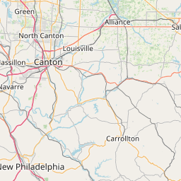
Stark County in northeastern Ohio...
Southeastern Summit County in northeastern Ohio...
* Until 200 PM EDT.
* At 112 PM EDT, a severe thunderstorm was located over Massillon, or
near Canton, moving east at 65 mph.
HAZARD...60 mph wind gusts and quarter size hail.
SOURCE...Radar indicated.
IMPACT...Minor damage to vehicles is possible. Expect damage to
trees and power lines.
* Locations impacted include...
Canton, Massillon, Green, Alliance, North Canton, Louisville,
Minerva, Hartville, Brewster, Navarre, Waynesburg, East Sparta,
Wilmot, Canal Fulton, East Canton, Beach City, Bolivar, Meyers
Lake, Hills And Dales, and Greentown.
Instruction:
For your protection move to an interior room on the lowest floor of a
building.
Area Description:
Stark, OH; Summit, OH
Forcast Office:
NWS Cleveland OH
Leaflet | OSM Mapnik