
Headline:
Severe Thunderstorm Warning issued April 3 at 6:50AM EDT until April 3 at 7:15AM EDT by NWS Baltimore MD/Washington DC
Event:
Severe Thunderstorm Warning
Urgency:
Immediate
Effective:
April 3, 2025 - 3:50am
Expires:
April 3, 2025 - 4:15am
Description:
SVRLWX
The National Weather Service in Sterling Virginia has issued a
* Severe Thunderstorm Warning for...
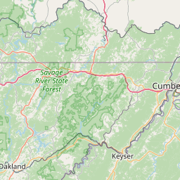
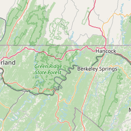
Western Allegany County in western Maryland...
Garrett County in western Maryland...
Central Mineral County in eastern West Virginia...
* Until 715 AM EDT.
* At 650 AM EDT, severe thunderstorms were located along a line
extending from near Friendsville to near Loch Lynn Heights, moving
east at 65 mph.
HAZARD...60 mph wind gusts.
SOURCE...Radar indicated.
IMPACT...Damaging winds will cause some trees and large branches
to fall. This could injure those outdoors, as well as
damage homes and vehicles. Roadways may become blocked by
downed trees. Localized power outages are possible.
Unsecured light objects may become projectiles.
* Locations impacted include...
Franklin, Lonaconing, Keyser, Dogwood Flats, Bittinger, Oakland,
Jennings, Woodland, Deep Creek Lake State Park, Mccoole, Swallow
Falls State Park, Deer Park, McHenry, Big Run State Park,
Friendsville, Piney Grove, McComas Beach, Kitzmiller, Merrill, and
Rawlings.
Instruction:
For your protection move to an interior room on the lowest floor of a
building.
Area Description:
Allegany, MD; Garrett, MD; Mineral, WV
Forcast Office:
NWS Baltimore MD/Washington DC
Leaflet | OSM Mapnik