
Headline:
Special Weather Statement issued March 31 at 6:49AM CDT by NWS Birmingham AL
Event:
Special Weather Statement
Urgency:
Expected
Effective:
March 31, 2025 - 4:49am
Expires:
March 31, 2025 - 5:45am
Description:
At 649 AM CDT, Doppler radar was tracking strong thunderstorms along
a line extending from near Haleyville to 7 miles northeast of
Fayette. Movement was east at 45 mph.
HAZARD...Wind gusts up to 50 mph.
SOURCE...Radar indicated.
IMPACT...Gusty winds could knock down tree limbs and blow around
unsecured objects.
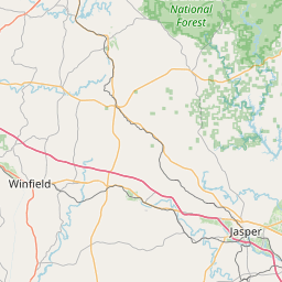
Locations impacted include...
Curry, Posey Field Airport, Houston Recreational Area, Camp McDowell,
Mill Branch, Clear Creek, Sumiton, Lynn, Smith Dam, Nesmith, Ashbank,
Winston County Airport, Cane Creek, Pebble, Bull Branch, Brushy Lake,
Coon Creek, Poplar Springs, Powellville, and Battle Branch.
Instruction:
If outdoors, consider seeking shelter inside a building.
A Severe Thunderstorm Watch remains in effect until noon CDT for
central, northwestern and west central Alabama.
Area Description:
Winston; Walker
Forcast Office:
NWS Birmingham AL


Leaflet | OSM Mapnik