
Headline:
Special Weather Statement issued April 2 at 3:32PM CDT by NWS Quad Cities IA IL
Event:
Special Weather Statement
Urgency:
Expected
Effective:
April 2, 2025 - 1:32pm
Expires:
April 2, 2025 - 2:15pm
Description:
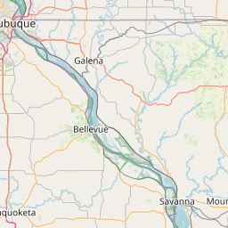
At 331 PM CDT, Doppler radar was tracking a strong thunderstorm over
Hanover, or 15 miles southeast of Galena, moving northeast at 35 mph.
HAZARD...Funnel clouds and possibly weak, brief tornadoes.
SOURCE...Radar indicated.
IMPACT...Isolated damage to roofs, siding and trees is possible.
Locations impacted include...
Hanover, Apple River, Whitton, North Hanover, Elizabeth Fairgrounds,
Schapville, Lake Le-Aqua-
na State Park, Massbach, Warren, Reeceville, Winslow, Apple River
Canyon State Park, Stockton Airport, Elmoville, Apple Canyon Lake,
Waddams Grove, Blanding, Green Island, Lena, and Canyon Camp.
Instruction:
If outdoors, consider seeking shelter inside a building.
This storm may intensify, so be certain to monitor local radio
stations and available television stations for additional information
and possible warnings from the National Weather Service.
Area Description:
Jackson; Jo Daviess; Stephenson; Carroll
Forcast Office:
NWS Quad Cities IA IL


Leaflet | OSM Mapnik