
Headline:
Special Weather Statement issued April 3 at 3:30PM CDT by NWS Shreveport LA
Event:
Special Weather Statement
Urgency:
Expected
Effective:
April 3, 2025 - 1:30pm
Expires:
April 3, 2025 - 2:00pm
Description:
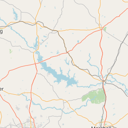
At 330 PM CDT, Doppler radar was tracking a strong thunderstorm over
Jefferson, or 16 miles north of Marshall, moving northeast at 40 mph.
HAZARD...Wind gusts up to 40 mph and pea size hail.
SOURCE...Radar indicated.
IMPACT...Gusty winds could knock down tree limbs and blow around
unsecured objects. Minor hail damage to vegetation is
possible.
Locations impacted include...
Pruett, Smithland, Lodi, Kildare, and Jefferson.
Instruction:
If outdoors, consider seeking shelter inside a building.
This storm may intensify, so be certain to monitor local radio
stations and available television stations for additional information
and possible warnings from the National Weather Service.
A Tornado Watch remains in effect until 1000 PM CDT for northwestern
Louisiana...and northeastern Texas.
Area Description:
Cass; Marion
Forcast Office:
NWS Shreveport LA


Leaflet | OSM Mapnik