
Headline:
Special Weather Statement issued April 3 at 6:15PM EDT by NWS Charleston WV
Event:
Special Weather Statement
Urgency:
Expected
Effective:
April 3, 2025 - 3:15pm
Expires:
April 3, 2025 - 3:30pm
Description:
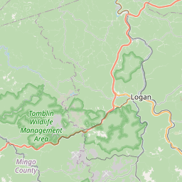
At 615 PM EDT, Doppler radar was tracking a strong thunderstorm over
Chief Logan State, or near Logan, moving east at 55 mph.
HAZARD...Wind gusts up to 40 mph and half inch hail.
SOURCE...Radar indicated.
IMPACT...Gusty winds could knock down tree limbs and blow around
unsecured objects. Minor hail damage to vegetation is
possible.
Locations impacted include...
Mount Gay, Chief Logan State, Verdunville, Holden, Chauncey, Switzer,
West Logan, Mount Gay-Shamrock, Logan, Blair, Mitchell Heights,
Sharples, Jeffrey, and Amherstdale-Robinette.
This includes Route 119 between mile markers 23 and 35.
Instruction:
If outdoors, consider seeking shelter inside a building.
This storm may intensify, so be certain to monitor local radio
stations and available television stations for additional information
and possible warnings from the National Weather Service.
Area Description:
Logan; Boone
Forcast Office:
NWS Charleston WV
Leaflet | OSM Mapnik