
Headline:
Special Weather Statement issued April 5 at 3:07PM CDT by NWS Houston/Galveston TX
Event:
Special Weather Statement
Urgency:
Expected
Effective:
April 5, 2025 - 1:07pm
Expires:
April 5, 2025 - 1:45pm
Description:
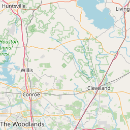
At 306 PM CDT, Doppler radar was tracking a strong thunderstorm near
Cut And Shoot, or 8 miles east of Willis, moving northeast at 35 mph.
HAZARD...Wind gusts up to 40 mph and half inch hail.
SOURCE...Radar indicated.
IMPACT...Gusty winds could knock down tree limbs and blow around
unsecured objects. Minor hail damage to vegetation is
possible.
Locations impacted include...
Cut And Shoot, Evergreen, Coldspring, and Conroe.
Instruction:
If outdoors, consider seeking shelter inside a building.
A Tornado Watch remains in effect until 900 PM CDT for southeastern
Texas.
Area Description:
Walker; San Jacinto; Polk; Montgomery
Forcast Office:
NWS Houston/Galveston TX


Leaflet | OSM Mapnik