
Headline:
Special Weather Statement issued April 5 at 3:30PM CDT by NWS Lake Charles LA
Event:
Special Weather Statement
Urgency:
Expected
Effective:
April 5, 2025 - 1:30pm
Expires:
April 5, 2025 - 2:00pm
Description:
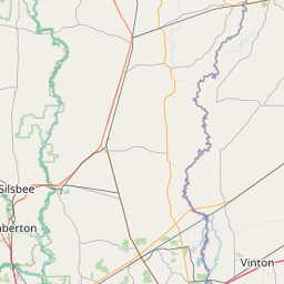
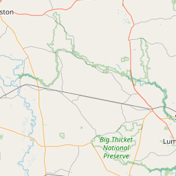
At 329 PM CDT, Doppler radar was tracking a strong thunderstorm over
Roganville, or 7 miles north of Kirbyville, moving northeast at 50
mph.
HAZARD...Wind gusts up to 50 mph.
SOURCE...Radar indicated.
IMPACT...Gusty winds could knock down tree limbs and blow around
unsecured objects.
Locations impacted include...
Newton, Jamestown, Farrsville, Roganville, Burkeville, Harrisburg,
Magnolia Springs, Mayflower, Wiergate, Kirbyville, and Jasper.
Instruction:
If outdoors, consider seeking shelter inside a building.
Frequent cloud to ground lightning is occurring with this storm.
Lightning can strike 10 miles away from a thunderstorm. Seek a safe
shelter inside a building or vehicle.
A Tornado Watch remains in effect until 900 PM CDT for west central
Louisiana...and southeastern Texas.
Area Description:
Northern Jasper; Northern Newton
Forcast Office:
NWS Lake Charles LA


Leaflet | OSM Mapnik