
Headline:
Special Weather Statement issued April 5 at 10:38PM CDT by NWS Jackson MS
Event:
Special Weather Statement
Urgency:
Expected
Effective:
April 5, 2025 - 8:38pm
Expires:
April 5, 2025 - 9:15pm
Description:
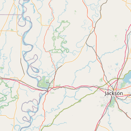
At 1038 PM CDT, Doppler radar was tracking strong thunderstorms along
a line extending from near Teoc to near Black Hawk to Eden. Movement
was east at 40 mph.
HAZARD...Wind gusts up to 50 mph.
SOURCE...Radar indicated.
IMPACT...Gusty winds could knock down tree limbs and blow around
unsecured objects.
Strong thunderstorms will be near...
Coxburg, Lexington, Brozville, North Carrollton, Carrollton,
Tolarville, Howard, Jefferson, and Emory around 1045 PM CDT.
Winona, Vaiden, and Bowling Green around 1050 PM CDT.
Elliott, Franklin, Ebenezer, and Duck Hill around 1055 PM CDT.
West around 1100 PM CDT.
Instruction:
If outdoors, consider seeking shelter inside a building.
A Tornado Watch remains in effect until midnight CDT for central and
north central Mississippi. A Tornado Watch also remains in effect
until 500 AM CDT for central and north central Mississippi.
Area Description:
Grenada; Carroll; Montgomery; Webster; Choctaw; Holmes; Attala
Forcast Office:
NWS Jackson MS


Leaflet | OSM Mapnik