
Headline:
Special Weather Statement issued April 6 at 2:52AM CDT by NWS Birmingham AL
Event:
Special Weather Statement
Urgency:
Expected
Effective:
April 6, 2025 - 12:52am
Expires:
April 6, 2025 - 1:45am
Description:
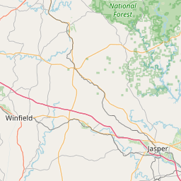
At 252 AM CDT, Doppler radar was tracking a strong thunderstorm 8
miles south of Kansas, or 8 miles southwest of Carbon Hill, moving
northeast at 50 mph.
HAZARD...Wind gusts up to 40 mph and half inch hail.
SOURCE...Radar indicated.
IMPACT...Gusty winds could knock down tree limbs and blow around
unsecured objects. Minor hail damage to vegetation is
possible.
Locations impacted include...
Curry, Camp McDowell, Mill Branch, Smith Dam, Nesmith, Ashbank, Coon
Creek, Poplar Springs, Powellville, Corona, Battle Branch, Hidden
Cove Campground, Townley, Black Pond, Eldridge, Wilson Bend, Devils
Branch, Kansas, Seymour Branch, and Duncan Bridge.
Instruction:
If outdoors, consider seeking shelter inside a building.
A Tornado Watch remains in effect until 1000 AM CDT for central and
west central Alabama.
Area Description:
Winston; Walker
Forcast Office:
NWS Birmingham AL
Leaflet | OSM Mapnik