
Headline:
Special Weather Statement issued April 15 at 5:01PM EDT by NWS Upton NY
Event:
Special Weather Statement
Urgency:
Expected
Effective:
April 15, 2025 - 2:01pm
Expires:
April 15, 2025 - 3:00pm
Description:
At 501 PM EDT, Doppler radar was tracking a strong thunderstorm near
Ogdensburg, or near Newton, moving east at 50 mph.
HAZARD...Wind gusts up to 50 mph and pea size hail.
SOURCE...Radar indicated.
IMPACT...Gusty winds could knock down tree limbs and blow around
unsecured objects. Minor hail damage to outdoor objects is
possible.
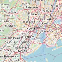
Locations impacted include...
Paterson, Wayne, Bloomfield, West Milford, Ridgewood, Monsey, Ramsey,
Ringwood, Pompton Lakes, Suffern, Caldwell, Hawthorne, Bloomingdale,
Fairfield, and Upper Greenwood Lake.
Instruction:
If outdoors, consider seeking shelter inside a building.
This storm may intensify, so be certain to monitor local radio
stations and available television stations for additional information
and possible warnings from the National Weather Service.
Area Description:
Western Passaic; Eastern Passaic; Western Bergen; Western Essex; Eastern Essex; Rockland
Forcast Office:
NWS Upton NY
Leaflet | OSM Mapnik